3D spectacle image around the Yakushima and Tanegashima Islands
The bottom of the sea around Yakushima and Tanegashima which are located the south of Kagoshima city are on the glaces continental shelf.
The sea on this images seen as lighter blue is shallow, and darker is deep.We can see the seafloor around here are approximately flat.
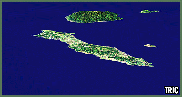
Tanegashima is flat and slim in the north and south. On the other hand,the high mountains are located in Yakushima. This island is suggented that rises from the bottom of the sea. Mt. Miyanoura that is in the center of this island is the highest mountain at Kyushu area. We can confirm from satellite images that there are many forest on the island. Yakushima was registered with world natural heritage in a conservation of nature area in 1993.
An island to see near Tanegashima is Mageshima, and the right neighbor of Yakushima is Kuchierabujima. There is a shallow trench (trough) in the bottom of the sea between Yakushima and Kuchinoerabujima . A mountain in Kuchinoerabu is an active volcano.
Satellite data:LANDSAT-7 ETM,ETOPO2 NOAA/NGDC
Image processing :東海大学情報技術センター
References:"Topography 6 ーKyushu, Nannsei islnds, Tokyo University publication society of Japan", 2001