
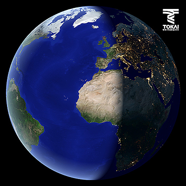
THE EARTH FROM SPACE
This is a satellite image of the earth using combined Terra and DMSP data aquired in April. Clouds were totaly removed and ocean bathymetry was expressed as color graduation in blue.
The area seen as green color is vegetation, white color is snow and ice, and bright brown color is mainly arid desert or mountain.
The weather satellite DMSP of American Department of Defense has ability to detect the city lights, fires, flames of the oil well, fisherboat lights in the night.
The Nile delta of North Africa where the Sahara desert extending can be seen. Since ancient times, most of Egyptian people have been living in the Nile valley.
Data : Terra MODIS / DMSP (NASA/NGDC)
▶ click here to see movie
■The 3D movie of Iriomote Island has been released [2021/08/04] New!
■About rebroadcast of TV program
TRIC cooperates with NHK in image processing of TV program "Great Summits, great mountains of the world(NHK BS Premium)