ISPRS Technical Commission VI Symposium
“E-LEARNING AND THE NEXT STEPS FOR EDUCATION”
 Tokyo, Japan, 27 - 30 June 2006

CATCON4 
Date: June 29, 2006
Time: 9:00-12:00
Place: Hoyer(Free Space)

Return to Symposium Page 

CATCON Homepage

What is CATCON ?

CATCON is the name of a software contest organized by the ISPRS Commission VI. The main objective of the contest is to promote the development and dissemination of good/user-friendly software packages, videos as well as data sets for computer assisted teaching(CAT). In general, the software or dataset should be non-commercial and should be provided to the users on free of charge.
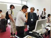
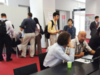
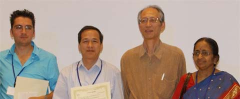
    The first CATCON was organized at the ISPRS Vienna Congress in 1996, the CATON2 at the ISPRS Amsterdam Congress 2000, and CATCON3 at the ISPRS Istanbul Congress 2004. 

CATCON4 Winners

   CATCON4 was organized at the ISPRS Commission VI Symposium in Tokyo in June 2006. Total of 14 software were demonstrated at the contest, and participants of the contest voted for their favorite software. Considering the result of the voting, the CATCON4 Jury selected the following winners. The prizes were given to the winners at the Closing Session on June 30. The CATCON4 Awards were supported by the ISPRS Foundation.

Award

Contestant

Entry

Web Site or email

Gold
US$1000

P. Venkatachalam
Indian Institute of Technology
India

E-Tutor for GIS

www.csre.iitb.ac.in/gram++

Silver 
US$700

Nguyen Dinh Duong
VAST
Vietnam

CARST 1.0

duong.nd@hn.vnn.vn

Bronze 
US$500

Diego Gonzalez Aguilera
University of Salamanca
Spain

SV3DVISION

daguilera@usal.es


from right to left

P. Venkatachalam
(Gold award winner)
Sunji Murai
(Award presenter)
Nguyen Dinh Duong
(Silver award winner)
Diego Gonzalez Aguilera
(Bronze award winner)

Nominated software (For details of the software, please click here)

(a) Software, (b) Name, (c) Affiliation, (d) How to obtain the software, (e) contact point

1. (a) CARST 1.0: Computer Assisted Remote Sensing Training package version 1.0
    (b) Nguyen Dinh Duong
    (c) Vietnamese Academy of Sciences and Technics
    (d) Via Website : http://www.geoinfo.com.vn/Products.asp?lang=en
    (e) duong.nd@hn.vnn.vn

2. (a) Satellite Image 3D Presentation System for Education
   (b) Kisei Kinoshita, Nobuya Tomioka, Hirotsugu Togoshi
   (c) Kagoshima University , Research and Development Center
   (d) Via Website : http://sipse.edu.kagoshima-u.ac.jp/sipse/index-e.htm 
   (e) kisei@rdc.kagoshima-u.ac.jp

3. (a) Limulator (LiDAR Simulator)
    (b) Bharat Lohani
   (c) Indian Institute of Technology Kanpur
   (d) Via Website : http://home.iitk.ac.in/~blohani/download.htm
   (e) blohani@iitk.ac.in

4. (a) eLearning program DTMchecking
    (b) M. Potuckova, M. Cabelka
    (c) Charles University in Prague
    (d) Via website : http://slon.fsv.cvut.cz/dtmchecking/  
    (e)  mpot@natur.cuni.cz

5. (a) WebMODIS and WebPaNDA
    (b) Wataru Takeuchi
    (c) University of Tokyo
    (d) Via website : http://webmodis.iis.u-tokyo.ac.jp/, http://webpanda.iis.u-tokyo.ac.jp/
 
   (e) wataru@iis.u-tokyo.ac.jp

6. (a) Step-by-step GIS
    (b) Akiko Takahashi
    (c) University of Tokyo
    (d) Via website (Testing): http://tekuteku.csis.u-tokyo.ac.jp/
           User-ID: ISPRS
           passwd: ISPRS
 
    (e) akuri@csis.u-tokyo.ac.jp

7. (a) FreeGIS
    (b) Kohei Arai
    (c) Saga University
   
(d) Both web site and e-mail : http://www.ip.is.saga-u.ac.jp/~arai/arai.html  
    (e) arai@is.saga-u.ac.jp

8. (a) Space on Palm
    (b) Daigo Hiruma
    (c)
Tokai University
    (d) Via website(Only Japanese so far): http://www.geocities.jp/chi_rin5050/spaceHP/
    (e) 1asp1115@keyaki.cc.u-tokai.ac.jp

9. (a) KML format conversion module for census data display using Google earth
    (b) Kiyotada Sato
    (c) Ichinoseki National College of Technology
    (d) Via website : http://www.ichinoseki.ac.jp/satok/H18/index.html    
    (e) satok@ichinoseki.ac.jp

10. (a) WIPS, Worksheet Image Processing System
      (b) Kiyotada Sato
      (c)
Ichinoseki National College of Technology
      (d) Via website (Only Japanese so far) : http://www.ichinoseki.ac.jp/satok/kyoiku/rs/INDEX.HTM  
      (e) satok@ichinoseki.ac.jp

11. (a) eLearning-Module about Spatial Database Systems
      (b) Antje Krüger, Thomas Brinkhoff
      (c) FH Oldenburg/Ostfriesland/Wilhelmshaven (University of Applied Sciences)
      (d) Via website : http://www.fergi-online.de
      (e) thomas.brinkhoff@fh-oldenburg.de

12. (a) E –Tutor for GIS (version 1.0)
      (b) P.Venkatachalam
      (c) Indian Institute of Technology
      (d) Via website : http://www.csre.iitb.ac.in/gram++
      (e) pvenk@iitb.ac.in

13. (a) YUI : Web-GIS for Connecting Region and Human
       (b) Shintaro Goto and Toshikazu Sakai
       (c) Rissho University
       (d) Via
website : http://gisportal2.ris.ac.jp/yui_index.html
       (e) sakai@gaia.ris.ac.jp

14. (a) sv3DVision (3D Reconstruction from a single view)
      (b) Diego Gonzalez Aguilera
      (c) University of Salamanca
      (d) The data set is available on CD and on the Internet(TBD)
      (e) daguilera@usal.es
 

 Secretariat  

For more details on CATCON : http://www.geomsoft.com/isprs6wg2/catcon.shtml

Koki Iwao, Dr. Eng,
CATCON4 local coordinator
ISPRS Commission VI
Center for Global Environmental Research
National Institute for Environmental Studies
E-mail: iwao.koki@nies.go.jp

Updated on September 11, 2006 by